Pages

Monday, 17 June 2013

Old Convict Road


Saturday 16th June 2013

The Old Convict Road starts in Orford just over the Prosser River bridge on the North side.
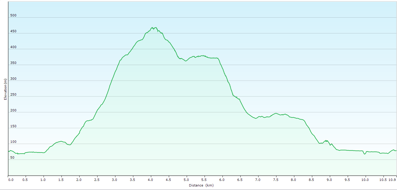
The day dawned overcast and drizzly but I decided to go for a walk anyway. The trip up to Orford took about 1.5 hours and it was showering most of the way. Undeterred, I set off in a light shower towards the Convict Ruins which I reached in about 20 minutes. The ruins consist mostly of piles of rocks but some parts of buildings can be recognised including what looks like the floor of a building made out of cobble stones. After a few photos the track continued on uphill to a power line and then via a foot track up a ridge to almost the summit of a hill before descending to an old track which was followed down to Burnt Bridge Creek. The track became the Old Convict Road once again and was quite easy to follow along the Prosser River for a time until it became indistinct once more, but thankfully someone had added pink tapes which make progress somewhat easier. After this section the road was more obvious and easy walking along the banks of the river. I had no real destination in mind, but when I reached the flying fox which spans the river I decided enough was enough as I was somewhat soaked. Once I had finished lunch the return journey was completed in fairly quick time and needless to say it started raining again when I was almost back to the car. Overall not a bad walk despite the weather.
Distance: 13.1 kms.
Time: 4'30"
Ascent: 550 metres
Click here to download GPX track.
Convict Ruins
                                                   
Flying Fox
                                                   
Prosser River
                                                 
Convict Ruins
                                               
Convict Ruins
                                                     
Convict Ruins


Wednesday, 10 April 2013

Mount Direction

Wednesday 10th April 2013

Summit Cairn Mount Direction
Mount Direction is a short walk in the Hobart area and the walk starts at the Risdon Brook Reservoir.
I walked across the dam wall at the reservoir and along the track on the left side before turning off on to another track and walking up hill to find the track to Mount Direction heading off on the left.
Reservoir Wall
The track climbed steadily uphill and became steep in a few sections. I reached the summit 1'30" after setting off. There were great views of Hobart and surrounds. I then walked back downhill for about 400 metres and then headed off track in a northerly direction along a ridge and the down to a road. From here I just followed the road back to meet the outward leg and continued down, before going off track to meet the track running around the reservoir. I then walked back to the car along the banks of the reservoir. There was a group of people sailing model yachts on the other side, which I watched for a while. It was quite interesting.
A nice short walk with good views on a clear day.
Distance: 10.9 kms.
Time: 3'38"
Ascent: 500 metres
Click here to download GPX track.
Mount Direction Summit

From the Summit

From the Summit

From the Summit

Risdon Brook Reservoir

Yacht racing on the Brook


Monday, 25 March 2013

Tom Thumb Circuit

Monday 25th March 2013

Summit cairn Tom Thumb
I parked in the large car park just uphill from Big Bend and set off walking at 0757. It was a beautiful clear day with a mild temperature so all was looking good. I walked back downhill to the Big Bend Trail which descended for 3.3 kms. to a cairn marking the start of Tom Thumb ascent.
Big Bend Trail
The climb to Tom Thumb summit was short and only took about 20 minutes. The views from the summit were very good. After a break I climb back down to the Big Bend Trail and carried on passing the Knights Creek Track on the right before meeting up with the East West Trail. I followed this for a while to the Myrtle Forest Trail junction and was met with a sign saying that the East West Trail was closed due to the fire damage. It had a phone number so I rang the ranger and was told that, indeed , the trail was open and they had missed taking down the sign. Thankful I carried on, now uphill to the Collins Bonnet Track and then more uphill to Mount Connection. As I reached the summit I deviated off track to check out The Lectern and Pulpit Rock, both worthy of a visit, and then back to the main track again. Eventually I reached the Big Bend Trail and completed the final climb to the car.
This was a good walk with great views around the Mount Wellington area. There is a bit of up and down but it is not too bad.
Distance: 15.6 kms.
Time: 6'10"
Ascent: 764 metres
Click here to download GPX track.

                                                          Various views from Tom Thumb Summit


                                                                  Various views from The Lectern


On the Collins Bonnet Track


Thursday, 28 February 2013

Wellington Falls Circuit

Thursday 28th February 2013

Wellington Falls
I parked the car at the car park just near the start of Pinnacle Road at Fern Tree and set off at 0730. I first walked back along Huon Road past the tavern and onto the start point of various tracks in the park . The first track I walked up was the Middle track followed by the Radfords track to The Springs and then up past the site of the old hotel, cosmic ray observatory and on to the Milles track. It was all uphill to this point, but best to do this early in the day, I say.
Cathedral Rock from Milles Track
The track climbed steadily passing the Ice House track on the right and kept on climbing, but not steeply before descending to Disappearing Tarn and The Potato Fields. There was no water in the tarn which is pretty normal and the Potato Fields which consists of many, many boulders which have to be negotiated, although this was not difficult. After this the track climbed steadily again to near the falls.
Potato Fields
The track now descended to the falls where there is a lookout and it is also possible to descend to the base of the falls. I opted not to do that today. From here the track descended all the way back to the car via the Wellington Falls track and Pipeline track.
Overall a good walk and even though it is quite long, much of it is easy, so it does not take a great deal of time.
Distance: 21.3 kms.
Time: 5'55"
Ascent: 630 metres
Click here to download GPX track.
Potato Fields
Top of Wellington Falls

Top of Wellington Falls
Saint Crispins Well

Montagu Thumbs from Pipeline Track

Cathedral Rock from Pipeline Track


Monday, 25 February 2013

Denmans Cove

Monday 25th February 2013

Denmans Cove
Denmans Cove is on the Tasman Peninsula. To reach the start of the walk turn right into old Fortescue Road about 5.5 kms. past Taranna and then after 300 metres right into Andersons Road. Drive for 1.2 kms. to a parking area and signs.
I set off at 0920 and walked uphill on an old track for 700 metres before finding the track on the right hand side. This descended steadily through some nice forest for a further 700 metres to Stinking Bay which is aptly named.
Arriving at Stinking Bay
It was a perfect day and the water was very calm. I walk along the track to the beach at the head of the bay, crossed Gathercoles Creek, which was only a trickle, and carried on up the beach to pick up the track again near the rocks.
Gathercoles Creek and Stinking Bay Beach
The track went inland then back to the coast and followed the coastline to Simmons Creek, which was easily forded and then kept going along the coast to finally arrive at Denmans Cove, some 4.0 kms. after setting off.
Arriving at Denmans Cove looking north
Denmans Creek flows into the cove so I walked up it a little way and found a spot for lunch and then after that I walked out on the rocks on the southern side of the cove. It was a picturesque place. There were views of Port Arthur and I could see the cruise boat sailing around the Isle of the Dead. After dwelling for a while I simply retraced my steps back to the car.
This is a great short walk with no great effort required and provides excellent coastal scenery.
Distance: 10.0 kms.
Time: 3'45"
Ascent: 320 metres
Click here to download GPX track.
Arriving at Stinking Beach

Denmans Creek looking out to the cove

Looking towards Port Arthur

Looking towards Port Arthur

Denmans Cove

Denmans Cove

Looking towards Stewarts Bay