 |
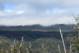
| Mount Snowy from Crib Hill |
I parked the car in Crib Hill Road just down from the locked gate and set off uphill. It was a gentle climb of 400 metres over 4.0 kms. to reach the plateau that is Crib Hill. There was no distinct peak.
The walk was on a good forestry track through some nice forest in places with some remnant large trees.
As I neared the plateau I could see some views of the Hartz Mountains through the trees but better views were to be had at the end of the road where there was a forestry coupe. I climbed up into the cleared section so I could see more but alas the cloud had come over and covered the peaks. Never the less it was quite scenic.
 |
| End of road and forestry coup around the corner on this hill |
 |
| Hartz Mountains |
 |
| Hartz Mountains |
 |
| Hartz Mountains |
I had seen the track that I wanted on the way up, so when I reached it, I followed it until it ran out also. The scrub didn't look too bad but it was about 400 metres down to the river and by this time I had had enough, so simply returned to the car.
 |
| The final track |
 |
| Large trees across track |
Distance:19.7 kms.
Time:5'12"
Ascent 645 metres
Click here to download GPX file.


No comments:
Post a Comment