Pages

Showing posts with label Judbury. Show all posts

Saturday, 20 July 2013

Bracken Ridge Trail

Saturday 20th July 2013

With the forecast of rain in the afternoon, I decided on a fairly straightforward walk close to home so I could finish early. Bracken Ridge Trail turned out to be the one.
From Judbury I drove up Bermuda Road, then on to Bermuda Link Road to the start of the walk on Bracken Ridge. The first 3.5 kms. were not really impressive as the road travelled through logged, burnt and replanted areas. After this it improved somewhat as the track changed to an old 4WD track through nice forest. As this descended to Southwood Road  the Ta Ann veneer mill came into view. There were good views of the surrounding mountains. It was then along Southwood Road to the bridge spanning the Huon River where I took some photos and then reversed direction and headed back to Edwards Link Road where I took a quick diversion to check out the Arve River which was flowing quite well. I then walked along Southwood Road for about 2.5 kms. to pick up the Williamette Creek 4WD track.This is a track set aside for four wheel drivers to test out their driving prowess. The track was okay to begin with but deteriorated to a pretty bad state in some places with deep water filled ruts which made the going rather slow. I could have done with 4WD walking up some of the hills as they were very slippery.
The forest in this section was very nice and the birds were singing well. After about 2 kms. the track emerged on to a good forestry road which I followed back to the car except for a minor deviation to an old track for the last 500 metres.
This was probably not a favourite walk but it was okay as I wanted to get a feel for the area.  I had not been there before and this provide a good introduction.
Distance: 15.2 kms.
Time: 4 hrs.
Ascent: 500 metres
Click here to download GPX track.


Mountain Views

Logged Area

Logged Area

Entering Nice Forest

More Mountain Views

And More

4WD Track on the Ridge

Huon River

Huon River

Arve River

Arve River

Williamette 4WD Track

Williamette 4WD Track

Wednesday, 26 June 2013

Mount Lloyd


Sunday 20th January 2013

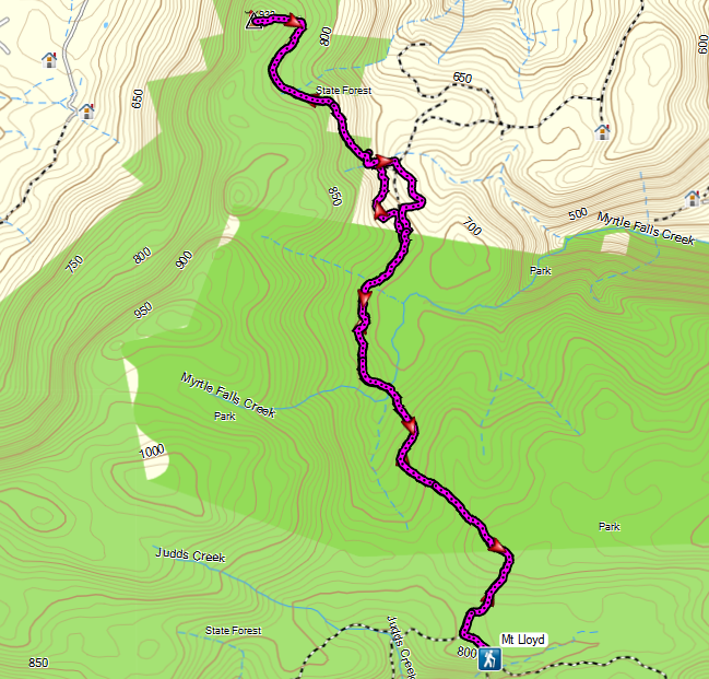
I drove up Judds Creek Road from Judbury to White Timber Fire Trail and eventually found the start of the walk thanks to information supplied by Peter Franklin on Share My Routes.
The walk started out on an old track that was quite overgrown which made long sleeves and pants a necessity. The first 3 kms. were not too bad but after crossing Myrtle Falls Creek the scrub had more or less reclaimed the original track and progress was somewhat slowed by the need for scrub bashing. I eventually broke out of the scrub into a forestry plantation where there was the option to turn either left or right. I choose left and walked along a pleasant track through the plantation where there were copious ferns.
It was not too long before I found the old track that led up to Mount Lloyd and it was quite easy walking. Up towards the summit the road consisted of solid rock in places which was quite interesting. Well, it turned out that the scrub bashing had been worth it as the views from the top were great, especially from the small fire tower. The return journey was via a different route around the plantation, but I could not avoid the scrub bashing after that. I arrived back at the car at 2.20pm. It was probably not a favourite walk, due to the scrub bashing, but the views were worth the effort.
Distance: 16.9 kms
Time: 6'30"
Ascent: 650 metres
There is a map and down loadable gpx file at Everytrail.
Click here to download GPX track.
Myrtle Falls Creek

Forestry Track

Forestry Track

On the summit track

Looking east from summit track

Fire Tower on the summit
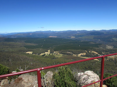
From fire tower

From fire tower

From fire tower

From fire tower

From fire tower

A road of solid rock