Wednesday 4th February 2015
Haymans Creek Falls
 |
| Haymans Creek Falls |
My intention today was to walk to Haymans Creek Falls(That is what I have named them as they don't seem to have an official name.) and also Fairy Falls.
I drove the back way from Judbury over to Arve Road and then to Arve Spur 5 which is a couple of kms. on the Geeveston side of the Hartz turnoff. The first thing I noticed was an open forestry gate and fresh tyre tracks so I proceeded to drive up the road until I came across a couple of guys washing down an excavator. I had concerns about being locked in if they happened to leave so I asked them about the gate and they suggested I would be better off parking on the other side of it just in case as there was still logging going on up the road. I wholeheartedly agreed so I retraced back to the outside of the gate and parked. Of course this meant a longer walk but that didn't matter.
When I walked back to the guys I could hear machinery working further up the road which I wanted to use for the walk. Not wanting to upset anyone I opted for plan B. Mind you I did not have a plan B so figured I would take another track which happened to be Arve Spur 5/1. This appeared to be heading roughly in the right direction. When it ran out I crossed a logged coup and entered the forest.
I soon came across a small creek which was flowing quite well. This was Harveys Creek.
 |
| Harveys Creek |
 |
| Harveys Creek |
I carried on heading in the general direction of the falls. The going was not real easy with lots of large downed trees to negotiate and then I came across some thick scrub which thankfully did not last too long. After this I started heading down to the creek quite steeply and made the mistake of entering the creek about 250 metres downstream of the falls.
 |
| Interesting old tree |
 |
| Rain forest type country |
It was not easy ascending the creek and I had to use both banks at times to finally reach the base of the falls. The falls were quite spectacular with a strong flow. I stopped for a snack before heading up the side of the creek. As I climbed I could see that the falls extended much further uphill than I had realised when looking from the bottom. I could not get any clear photos from here so did not bother.
 |
| Haymans Creek Falls |
 |
| Haymans Creek Falls |
 |
| Pool at base of falls - spot the Loch Ness Monster |
 |
| Base of falls |
It was really, really steep ascending out of the creek and I had to negotiate around vertical rock faces, but it soon flattened out somewhat. As I could not hear any machinery working I decided to head back the way I had originally planned to walk, guessing they were on lunch break. This worked out well as I finally reached the road. However, before this, I did come across a line of red and orange tapes which appeared to be indicating a track. I followed for a short distance, but when they appeared to be heading away from my plan, I abandoned that idea. The walk back to the car along the road was easy and all I spotted was a fully laden log truck. The two guys and their machinery were gone and the gate was still open. Better to be sure than sorry, I guess as there was definitely no way to drive around the gate if it was locked.
This was quite a good walk but the way I came back was much better with much less scrub.
Distance: 8.3 kms.
Time: 4'30"
Ascent: 320 metres
Click here to download GPX file.
Fairy Falls
 |
| Fairy Falls |
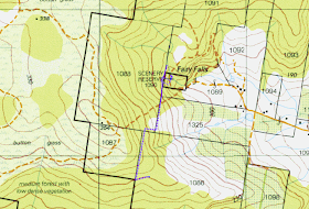
Once back in the car I drove along Arve Road towards Geeveston and turned into Arve Spur 4. I drove along this for a couple of kms. and found a parking spot. The walk went uphill then downhill to the falls along a forestry track. It was easy walking and I soon found a spot to descend to the base of the falls. The falls were quite pretty with a delicate curtain of water flowing down the face. It was very green and mossy here. I simply retraced back to the car.
This was an easy short walk and the falls are worth a visit but only if there is a decent flow. I suspect that the falls may be accessed from Fairy Falls Road but I don't know about private property that way.
Distance: 2.3 kms.
Time: 50"
Ascent: 170 metres
Click here to download GPX file.
 |
| Fairy Falls |
 |
| Fairy Falls |
 |
| Greenery around Fairy Falls |
 |
| Looking down the creek at Fairy Falls |
 |
| Fairy Falls |


No comments:
Post a Comment