Pages

Monday, 30 September 2013

Prosser Sugarloaf

Sunday 29th September 2013

Today I was thinking of going to Nevada Peak but when I looked out the window this morning the peak was shrouded in cloud and even the line of hills before it were not visible so I abandoned that plan and chose to do Prosser Sugarloaf instead. I don't mind walking in cloud at all but I do like to have some sort of view when I finally get there.
Additional information on Prosser Sugarloaf from Wielangta Road is at Rockmonkeyadventures or Prosser Sugarloaf via Twamley at Bushwalks.
Sandspit River
I arrived at the small parking area on Wielangta Road after a one and a half hour drive and set off walking at 0840. I could hear a chainsaw not far away and after I crossed the bridge over the Sandspit River I could see a guy cutting up a tree that he had felled just inside the forestry gate. After we exchanged a few pleasantries I continued on my way. Just as a bit of information it appears that this gate is never locked and only held shut by a small twig inserted where the lock should be. Consequently, I could have driven to within about 1 km. of Prosser Sugarloaf and had a very short walk but that would be hardly worth it.
Anyway I continued on up the road which rises steadily for 500 metres over 6 kms. This is a well maintained forestry road and is easy walking.
Good forestry road
Minor forestry road
After about 5 kms. of walking a minor track branched off to the left and this was quite wet and muddy in places but quite okay for walking.It was obvious that this is a very popular area for cutting firewood as there was evidence everywhere of felled trees and logs cut or marked for cutting. The forest in this area was rather pleasant to walk through although a fire had passed through here not so long ago. There were copious amounts of all sorts of wild flowers about and there were many birds singing in the trees.
At about 6.5 kms. of walking the track descended fairly steeply and crossed Wielangta Creek, which was only a trickle, really. It was amazing the change in the vegetation in dropping down to the creek as it went from dry eucalypt forest to more of a rain forest and was quite wet underfoot in places.
The track then climbed after the creek and eventually I came to a T junction. I opted for the right track and followed this around for 0.5 kms. or so before heading off track up a ridge that appeared to be heading in the right direction to the summit. It was then just a matter of rock hopping and climbing over downed trees to head in a south easterly direction to the summit. Care had to be taken on some of the rocks as even large ones tended to move underfoot.
I reached the summit at about 1130 and had a bite to eat. The views from here were very limited because of the trees but it was possible to see a little to the north and south. There was a trig marker and sort of a cairn here. I didn't spend too much time at the summit and then headed down in a close to northerly direction to meet up with a track. Just before reaching the track the forest became rather thick and required a bit of effort to get through. This track was followed back to the previously mentioned T junction, thus completing a small circuit.
All I did then was retrace my steps back to the car. I did take a small detour to check to see if there was another track that would cut across where the main road had a large sweeping bend, but could not find anything useful. I arrived back at the car at 1355, the timber cutter had gone and the forest was peaceful once more.
Distance: 16.7 kms.
Time: 5'13"
Ascent: 860 metres
Click here to download GPX track.
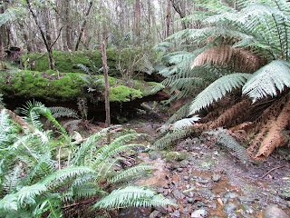
Wielangta Creek

Summit

North from summit

Maria Island from main forestry road


Sunday, 22 September 2013

Mount Montagu

Saturday 21st September 2013

Mount Montagu from Thark Ridge
It has been a couple of weeks since I have been able to get out for a walk and that has been because my partner had a triple fusion in her foot and I have been her nurse for that time. That has been quite okay, but I have been keen to get the body moving once again, and, as she is now a little more independent, I thought today would be the day.
There are a few different ways of walking to Mount Montagu and this is just one of them, starting at Big Bend and walking Thark Ridge to finally reach the summit.


The weather forecast was promising for today, so I drove to Mount Wellington and parked in the large car park just up from Big Bend and started walking at 0745. I had walked part of the Thark Ridge track last year when I did the Devil's Throne circuit so it was quite familiar. After a distance of about 1 km. the track has been rerouted uphill slightly for a few hundred metres to obviously avoid some of the wet area. The track was wet here and there but I had expected that as there had been some recent rain. The track basically follows the ridge on the southern side before climbing up to the top of the ridge where it becomes relatively flat along the ridge line.
Collins Bonnet from Thark Ridge
Along the ridge there are good views from different locations and there is a good lookout, marked with a large cairn, slightly off the track and just before the descent begins. From a little further on from here, Mount Montagu finally came into view. It looked a long way away. I continued on going down over some large boulders before coming out on the open area between the ridge and Mount Montagu. This was extremely wet with the water forming a small river running down the track but it was possible to avoid the water, mostly, although it made the going somewhat slow.


Eventually the track met up with an old fire trail/road which was quite overgrown but very easy to follow to a couple of cairns that mark the start of the track to the summit of Mount Montagu.
Cathedral Rock and Montagu Thumbs from Thark Ridge
The ascent was quite easy, although the track was poorly marked, it was not a problem following it to eventually come out in an open area at the summit with stunning 360 degree views. As it was a clear day the visibility was really good so I took a few photos, had a bite to eat and then headed down.
I wanted to check out Norris Hut which I had heard about, so once down to the fire trail again I went south west for 1.3 kms. to find the hut. The going was quite easy but the track is becoming overgrown and the final descent to the hut was very wet. Apparently, the hut was built by a Mountain River family and is set against a large piece of rock.
Norris Hut
Anyway, I didn't waste too much time here and began to retrace my steps back to the car. I did take note of the large cairn that marks the start of the track down to Wellington Falls for future reference. I found the climb back up to the top of Thark Ridge quite tiring and was glad when I finally reached it. The walk along the ridge was not much better, even though it was relatively flat, the constant rock hopping was becoming laborious. It was pleasing when the tower on Mount Wellington finally came into view, but it seemed to take forever to get back to the car which I eventually reached at 1530.
Overall I would rate this as a good walk, although I found it tiring. Maybe my age is starting to catch up with me, but I can't see myself stopping anytime soon.
Distance: 17.0 kms.
Time: 7'42"
Ascent: 800 metres
Click here to download GPX track.
Mount Montagu Trig marker

Mountain River from Mount Montagu

Collins Bonnet and Trestle Mountain from Mount Montagu

From Mount Montagu

Mount Wellington and Thark Ridge from Mount Montagu

Cathedral Rock and Montagu Thumbs from Mount Montagu


Thursday, 5 September 2013

Tatnells Hill Circuit

Wednesday 4th September 2013

I had previously walked to Tatnells Hill a couple of years ago, but only from Waterfall Bay, so this circuit walk that I made up was going to be a new experience.
This morning I left home at 0600 and drove down to Eaglehawk Neck where I parked the car 100 metres into Blowhole Road off the Arthur Highway. As it was going to be a fairly long walk I wanted to get an early start so it was about 0745 when I commenced walking.
The walk went in a southerly direction for 300 metres to a sign indicating a track to Cashs Lookout. I went up this track for a short distance and found another sign lying in the bushes and followed this track which alternated between an overgrown road and an overgrown walking track. The long and the short of it is that I lost the track altogether, so I decided to head steeply uphill to the ridge line that I could see, and where I suspected the track would be. The walking was quite easy as the area had been burnt in the fires last year and when I reached the top of the ridge, sure enough the track was there. This track was  poorly marked as I suspect that the fires had destroyed many of the tapes and there were some large trees down also, but it was really just a case of following the ridge line up to Cashs Lookout.
At Cashs Lookout there is a hang glider launching pad with excellent views of Eaglehawk Neck and Pirates Bay but unfortunately today it was quite hazy in the distance. From here the walk was down Plateau Road for 2.8 kms. to Lichen Road which was followed for 1 km. to a sign indicating the start of the track to "Tatnells Hill via Lichen Hill". This track was flagged and marked with pointers, but I suspect that it is not used very much, and it was possible to loose the track on a few occasions, but generally not too difficult to find. At first the track went through wet forest with lots of moss and lichens and then once the ascent to Lichen Hill was reached it became quite dry. There were reasonable views on the approach to Lichen Hill where I stopped for a short break. After this the descent from Lichen Hill went into wet forest once again before finally reaching Tatnells Hill. I did not spend any time here but headed on down to the junction with the Tasman Trail where I had lunch.
After the break I just followed the track down, passing Camp Falls which had more water flowing over it than last time I was here, Waterfall Bay and then on to Tasman Arch. I really love the scenery along this part of the coast with the high sea cliffs. As I was venturing out on a rocky ledge to take a photo I looked down and here was this snake coiled up and sunning itself. I suspect it was a Tiger Snake, but I am no expert, I just leave then alone.
Once I reached Tasman Arch I found a somewhat overgrown track that went around the coast and eventually came out at the Blowhole carpark. It was along this track that one could stand right on the edge of the cliffs and watch the waves breaking 60 or 70 metres below. Quite spectacular. I then descended to Egg Beach and walked along this around a few rocky headlands for 3 kms. back to the car. I suspect it would not be possible to do this if the tide was in. I was rather glad to get back to the car as it had been a long walk but it was also an enjoyable one.
It is possible to access parts of this walk by car eg. Cashs Lookout via Plateau Road, Tatnells Hill via Balts Road, Tatnells Hill via Waterfall Bay Road and of course from Tasman Arch and Blowhole.
Distance: 20.9 kms.
Time: 6'30'
Ascent: 870 metres
Click here to download GPX track.
Pirates Bay from Cashs Lookout

Hang Glider pad Cashs Lookout

Walking track to Tatnells Hill

From Lichen Hill

From Tatnells Hill

Camp Falls

Sunny disposition

Waterfall Bay

Along the coastline

Patersons Arch

Looking towards Cape Hauy

Along the coastline

A long way down

Egg Beach