Thursday 31st October 2013
 |
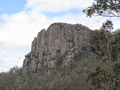
| Cathedral Rock from Montagu Thumbs |
I started the walk at a small car park beside the North West Bay River in Betts Road at about 0730. Previously I had walked to Cathedral Rock, Mount Montagu and Wellington Falls, but had not walked the circuit before.
The walk followed the North West Bay River for a time before linking up with an old fire trail which headed steeply uphill before flattening out somewhat. Soon the turnoff to Cathedral Rock was reached and I walked this to eventually reach Cathedral Rock 2 hours after I started. The track up to the rock is being eroded in places and is quite steep and rocky.
After a snack I headed off in the direction of Montagu Thumbs. It was quite blowy up here and I had to be careful walking along the narrow ridge. I would suggest that if one did not have a head for heights, then I would avoid this part of the walk as it is a very narrow ridge in places with steep drops on both sides. There are also a couple of tricky sections where long arms and legs are required, but other than that, it is okay. The track was easily followed.
 |
| Montagu Thumbs from Cathedral Rock |
About 3 hours into the walk I reached a lookout point along the Montagu Thumbs and stopped for a short time to check out the view and take some photos. I continued on down, then up over the last hill and then down again to finally reach the old Montagu Fire Trail. I was now in familiar territory as I had walked this section when I visited Norris Hut about 6 weeks ago.
Four hours from the start I came across the turnoff to Wellington Falls and walked this track to the Falls. This section of track was quite poorly marked and hard to distinguish in places but I finally arrived at the top of the Falls after about half an hour. There was a reasonable amount of water flowing down the river and this proved to be an ideal spot for lunch. After a short break I crossed the river and connected up with the Wellington Falls track which I walked down to the Pipeline Track. From here I followed the Siphon Track down to the North West Bay River. This track was very steep and I had to walk sideways in some places to avoid slipping down. Needless to say, my knees were protesting by the time I reached the river.
Just as I was approaching the river, I came across a class of school children and teachers out on a day excursion. Lucky kids - I did nothing like that when I went to school those many years ago!! After a bit of a chat, I crossed the river and found the track which led back to the track I had taken earlier in the morning and walked back to the car.
This was a good walk although quite a tiring one. I think I must be getting old!!
Distance: 14.6 kms.
Time: 6"34"
Ascent: 1016 metres
Click here to download GPX track.
 |
| North West Bay River from Cathedral Rock |
 |
| Collins Bonnet from Cathedral Rock |
 |
| Montagu Thumbs |
 |
| Mount Montagu |
 |
| Above Wellington Falls |
 |
| Montagu Thumbs from Wellington Falls Track |
 |
Cathedral Rock from Wellington Falls Track
|


