Pages

Tuesday 25 September 2018

Ridge near Collins Bonnet

Tuesday 25th September 2018

The Summit of the Ridge

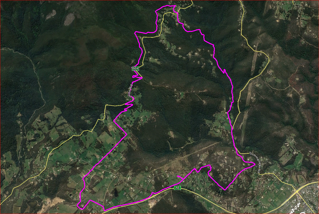
I had been eyeing off this ridge for a while, and as it had some rocky outcrops, I thought it was worth a visit. The ridge is north of Collins Bonnet and runs for a fair distance but I only walked the real rocky section where I suspected there would be good views. I was not disappointed.
I set off from Myrtle Forest and here I made my first mistake. I intended coming back along the Myrtle Forest Trail and should have had enough foresight to check if it was still open as I had not walked it for some years. Anyway, I did not. The Myrtle Forest Track was also supposedly closed due to flood damage but only a small section where it runs beside the creek was washed out and it was fine after that to the Collins Bonnet turnoff. The falls were flowing well.
Note: Do not use the Myrtle Forest Trail as there is a Parks sign at both ends stating that it is closed because of erosion and it also crosses private property. It is also severely overgrown.

Myrtle Forest Falls
I headed up the Collins Bonnet track to a point where I wanted to head up to the ridge. The scrub was quite thick but as I knew it was only a short distance to the scree, I persisted and was soon in the clear. It was a steepish climb up to the ridge and soon the views started to appear. As I neared the top some large rocky outcrops came into view. I could see a gap in the cliffs so I headed for that and that provided good access to the top of the ridge.

Near the top

Heading up to a gap in the cliffs

First bit of snow

Collins Cap

Looking north
The ridge provided quite easy walking and there some great rocks that provided clear views.

The Derwent


Collins Bonnet

Looking North

Looking North East
It was about this stage that it started snowing lightly as I made my way up to the peak. It was not quite the highest point but it was as far as I intended to go.

More Snow

A very steep and deep crevass

Rocks at the peak
Collins Bonnet with the emergency shelter in the foreground


I headed down to the main track through some more annoying scrub. It started snowing heavier.

It is snowing
I soon reached the track and headed for the emergency day shelter below Collins Bonnet for a break and some lunch and to get out of the snow.

Snowing on the East West Trail

Snowing on the day shelter
After warming up I ventured out again along the East West Trail  and very soon the snow stopped and the sun appeared. It was rather pleasant. I carried on to The Myrtle Forest Trail where I saw the track closure sign.

Mount Connection in the sun
 There was no way that I was going to retrace my steps back uphill. It would have made me too late getting home so I just walked down the trail to Myrtle Forest. The track was badly eroded, badly overgrown and there were signs of habitation on the private property. I arrived back at the car cold and wet but had a good day.
This was a good walk with great scenery from the ridge but of course it is not recommended to use the Myrtle Forest Trail. An out and back walk would be the better option and carrying along the ridge further would also be worth a go.
Distance: 11.6 kms.
Time: 5'38"
Ascent: 740 metres
GPX file is here.


Thursday 20 September 2018

Grassy Point

Thursday 20th September 2018

Grassy Point
Just a short walk today starting and ending at Pioneers Park in Sorell.
I set off and did a little loop of Pioneers Park, crossing the Sorell Rivulet and then walking the track until it was going to cross the rivulet again. Here I just started heading down the rivulet to the shore at Pitt Water. It was a little muddy in places but nothing to worry about and soon I was walking along a flat beach.

Pioneers Park

Pioneers Park

First Crossing Sorell Rivulet

Second Crossing Sorell Rivulet

Heading down the Rivulet

Where the Rivulet meets Pitt Water
The beach was a mixture of sand, shells and rocks but very easy walking. I just carried on along the coastline to Grassy Point.

Towards Five Mile Beach

Lewisham

Mount Garrett

The Shoreline

Shelly Beach

The only "Cliffs" on the walk
Once Grassy Point came into sight I walked right out to the end and back on the other side. There were a few little ponds or tarns out on the point.

Grassy Point

Grassy Point

Grassy Point

Grassy Point
Iron Creek Bay
Iron Creek Bay

Grassy Point
Walking back to the shoreline became a bit muddier as I neared the beach but once again it was not bad enough to cause any concern. I just kept going until I reached the new bridge over Iron Creek for the Arthur Highway and scrambled up to the road and walked the road verge back to the car via Coles car park.

Iron Creek Bay

Iron Creek Bay

Iron Creek Bridge
This was a good little flat walk with some nice scenery. It is probably best if done at low tide.
Distance: 10.7 kms.
Time: 2'29"
Ascent: 100 Metres
GPX file is here.


Tuesday 11 September 2018

Westringa Circuit

11th September 2018

Small tributary of Browns River on the Westringa Track
I have had the Westringa Track on the list for quite a while but to make it a worthwhile walk I decided to combine it with the Pipeline, Picket Hill and Leslie Vale Tracks to create a larger circuit.
I parked on the corner of Huon Road and Morphetts Road and headed up to the Pipeline Track and then walked about 3 kms. to Grays Road. It was nice walking at that time of day.

Pipeline Track

From Pipeline Track

Pipeline Track

Pipeline Track
I walked down Grays Road, crossed over Huon Road and then down Westringa Road to the end where the Westringa Track starts. This is a combination of an old vehicle track and further down just a bike track. I was really surprised as it was very pleasant walking all along the track and was the highlight of the walk in my eyes.

Westringa Track

Westringa Track

Tributary of Browns River

Westringa Track

Westringa Track

Isolated clump beside the track

Browns River
It was about 3.0 kms. down to Scotts Road and mostly all downhill. I then walked Summerleas, Old Summerleas Roads, and Hackford Drive to the start of the Picket Hill Track.

Browns River from bridge in Summerleas Road

Nice Wattle in Hackford Drive

Picket Hill Track
 I carried on along the Picket Hill Track and then up to the lookout in Parkdale Drive. It was very clear and there were good views all around.

The Derwent and Kingston

The Channel

Cathedral Rock

Mount Wellington
I kept going and picked up the Leslie Vale Track and walked it to its end in Bullock Drive. It was a bit wet in places and had been churned up by horses but was generally quite good.

Leslie Vale Track
From Bullock Drive there was a walk of about 4.0 kms. up Wolfes Road and Huon Road back to the car.

In Wolfes Road

From Wolfes Road
This was a good walk all on mostly reasonable tracks and it provided a great opportunity to stretch the legs.
Distance: 19.5 kms.
Time: 4'55"
Ascent: 700 metres
GPX file is here.