Pages

Tuesday 26 September 2017

Arve Plains to Tahune

Tuesday 26th September 2017

Arve Plains
When I walked Arve Plains about three years ago I could not find a track on the western end that appeared to head towards the river. This time I wanted to start near the western end and walk down to Tahune and back.
I parked in the quarry at the start of the walk, actually on the second tier of the quarry, so I could get my car out of sight due to the amount of burnt out cars in this vicinity. Today I saw three but I have seen quite a few in the past as well. It was a relief to find the car intact on my return.
I set off westward on Edwards Road and walked a short distance before turning right on to an old track. This was seriously overgrown but just manageable. Once I reached the flat plain the track became more like a lake or stream and the option of keeping the boots dry soon went out the window.
The Track

The Track
 The track headed north west and then west over towards the river. It alternated between puddles, lakes, streams and the occasional solid ground. The track was just discernible but was quite overgrown.
Nice lichen section of track

Nice mossy section of track
Once I reached the end of the heath section on the map and where it started heading south, it became more of a foot pad with the occasional and quite rare tape. This section of track from here to Tahune was quite easy to loose and I spent some time searching for it on numerous occasions, especially where trees had come down and blocked the track. There were wet sections through here as well and a nice little creek.
Track and rare tape

Large tree beside track

Lovely little creek and cascade
Just before I began heading west again the track came close to the Huon river so I was able to get a couple of shots. The river was flowing well from recent rain.


I continued following the track along the river towards Tahune and about 250 metres before the main road, I noticed an old side track the appeared to be heading in the right direction to meet up with Edwards Road. I decided to take it and it was a less than desirable decision. The track had actually become a  flowing stream and was up to 20cms deep in places. I paddled upstream for about 500 metres and then the track started to deviate away from Edwards Road. I could not bring myself to walk back and then out to the main road, so made the decision to bush bash to Edwards Road. There was some cutting grass but it was not as bad as I expected, and it was a relief to finally reach the road.
The track or flowing stream
Once I reached Edwards Road it was an easy amble of 5.5 kms. back to the car. When I reached the car I climbed up to the top of the quarry and took a couple of shots of the surrounding countryside.


On the way home I also stopped at the bridge over the Arve River to take a couple of photos.
Arve River

Arve River
This was an interesting walk, quite hard work in places with the scrub and not much in the way of scenery except for nice wet forest, but I am glad I have done it.
Distance: 13.4 kms.
Time: 4'36"
Ascent: 300 metres
Click here to download GPX file.


Friday 22 September 2017

Waddamana Power Station Museum

19th September 2017

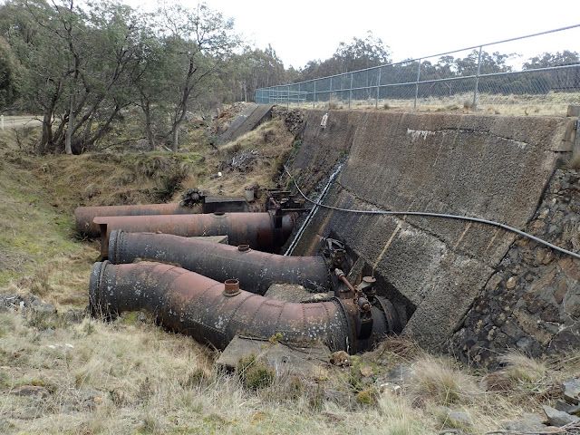
Obviously this is not a bush walk and nor is it in the south east of our state but I recently had the pleasure of visiting this museum at Waddamana north east of Bothwell so I am including a few photos for the history buffs who have not visited the site. This power station supplied the first hydro- electric power for Hobart.
To get there drive north on the A5 from Bothwell and turn left onto the C178 road 15.6 kms. from Bothwell. The C178 is a 2WD gravel road and forms a loop that comes back onto the A5 further north. There are signs indicating the way.
The museum is beautifully maintained and there is a wealth of information and memorabilia to see on sight. Set aside a few hours to get a feel of the place. Entry is free and the museum is open from 10am to 4pm daily except for a couple of public holidays. There is a self guided tour.  For more information see the Waddamana Power Museum Site. 
After the museum visit Penstock Lagoon, a little further north, which supplied the water for the power station.


Sunday 17 September 2017

Donkeys Track Point

Sunday 17th September 2017

Donkeys Track Point-the furthest of the closest hills
I have been thinking of going to Donkeys Track Point for some time, mainly because I liked the sound of the name. Donkeys Track Point is located about 2.6 kms. north west of the trig marker on Three Thumbs near Orford.
I headed off up the Three Thumbs track and made good time up to the trig marker.
Trig Marker Hill
Trig Marker Summit

From Trig Marker Hill

Shelter on Trig Marker Hill

From Trig Marker Hill
 From here I headed down and then up to the final Thumb before starting the long descent to a saddle way below. It was very rocky going down before the country opened up and became an open dry forest which was very pleasant to walk through.
From western end of last thumb

Heading down from last thumb

Nice open forest walking

Nice open forest and next hill to climb in the distance
I walked across the saddle and started the ascent of the next hill. It was still easy walking and very little scrub. It did not take long to reach the summit where there were some good views out to the west.
To the west

To the west

Starting the descent

Donkeys Track Point
From here I could see the hill where Donkeys Track Point is located and started the final descent to another saddle before beginning the climb up to Donkeys Track Point. From the saddle there were limited views of Orford.
View of Orford from last saddle

Heading up to Donkeys Track Point


Donkeys Track Point


Donkeys Track Point and lunch spot
The climb up to Donkeys Track Point was not much and I soon arrived at the destination. Basically it is a large flat area on top of a hill. It is very nice forest and easy walking. I stopped for lunch before having a wander around and then started heading back. I took a slightly different route back to the second saddle but it was not a good idea as it was more scrubby and I ended up descending more than I needed to...the direct route is the preferred route. I climbed back up to the last thumb and that was a bit of a drag, crossed over it and climbed up to the trig marker. I managed to take a couple of shots up near the top
Orford

Orford
From here it was an easy amble downhill to the car via the forest loop walk.
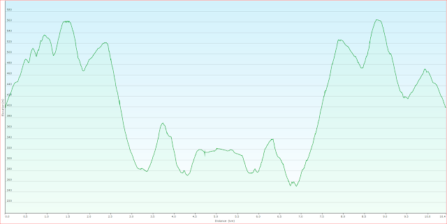
This was a good walk through some nice forest but it was also somewhat tiring due to the ups and downs. The majority of the walk is off track but navigation is quite easy.
Distance: 10.4 kms.
Time: 5'55
Ascent: 915 metres
Click here to download GPX file.