Pages

Showing posts with label Mount Lloyd-South East. Show all posts

Tuesday, 15 December 2015

Mount Lloyd

Tuesday 15th December 2015

Looking along the ridge from Mount Lloyd
I just wanted to do a short walk today, and even though I have been to Mount Lloyd before (See Here) from the south, I opted for the straight up route from the western side. Access is via Glenfern Road and Mount Lloyd Road and park on the corner of Mount Lloyd Road and Paddy Flats Road.
I set off up an access track and when this ran out I headed more or less east through the scrub towards the summit. The scrub was okay in places but some sections were starting to regenerate and progress was slowed on a few occasions. Up towards the top it became very steep, and was hands and knees stuff some of the way with very mobile scree. I made it without incident but was determined to find a better way down.
It was a reasonably clear day and the views were very good.
Forestry from summit

Mount Lloyd town

Looking north east

Looking north west

Looking towards Wellington Range

Looking towards New Norfolk

Communications set up

Looking over the edge

Looking up towards the range to the south of Mount Lloyd

Section of open rock near summit
After a snack I headed south along the ridge top to try and find a better way down. This I did when I came across a gully that sloped down at a much better angle than what I had encountered on the ascent. This would be a much better route to use to the summit. It was fairly easy going with some scrub and I made it back to the car with no dramas.
This was a good short little walk and the views on a clear day are really good.
Distance: 5.6 kms.
Time: 3'55"
Ascent: 455 metres
Click here to download GPX file.


Wednesday, 26 June 2013

Mount Lloyd


Sunday 20th January 2013

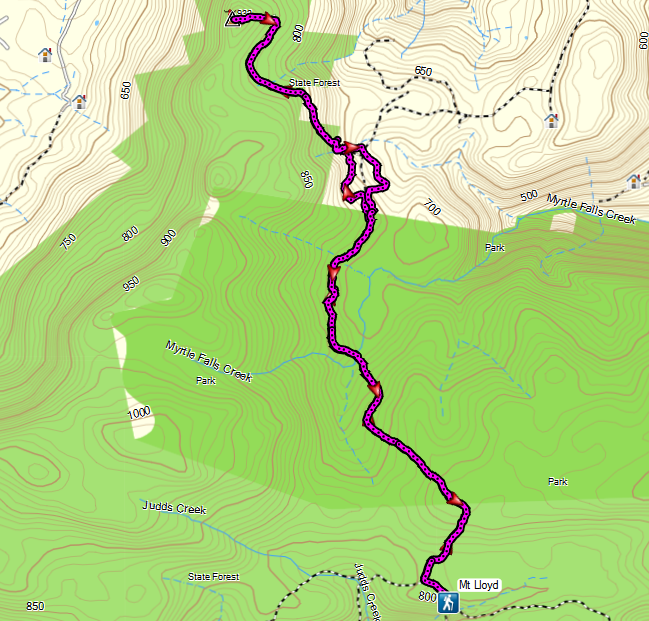
I drove up Judds Creek Road from Judbury to White Timber Fire Trail and eventually found the start of the walk thanks to information supplied by Peter Franklin on Share My Routes.
The walk started out on an old track that was quite overgrown which made long sleeves and pants a necessity. The first 3 kms. were not too bad but after crossing Myrtle Falls Creek the scrub had more or less reclaimed the original track and progress was somewhat slowed by the need for scrub bashing. I eventually broke out of the scrub into a forestry plantation where there was the option to turn either left or right. I choose left and walked along a pleasant track through the plantation where there were copious ferns.
It was not too long before I found the old track that led up to Mount Lloyd and it was quite easy walking. Up towards the summit the road consisted of solid rock in places which was quite interesting. Well, it turned out that the scrub bashing had been worth it as the views from the top were great, especially from the small fire tower. The return journey was via a different route around the plantation, but I could not avoid the scrub bashing after that. I arrived back at the car at 2.20pm. It was probably not a favourite walk, due to the scrub bashing, but the views were worth the effort.
Distance: 16.9 kms
Time: 6'30"
Ascent: 650 metres
There is a map and down loadable gpx file at Everytrail.
Click here to download GPX track.
Myrtle Falls Creek

Forestry Track

Forestry Track

On the summit track

Looking east from summit track

Fire Tower on the summit

From fire tower

From fire tower

From fire tower

From fire tower

From fire tower

A road of solid rock