Sunday 17th September 2017
 |
| Donkeys Track Point-the furthest of the closest hills |
I have been thinking of going to Donkeys Track Point for some time, mainly because I liked the sound of the name. Donkeys Track Point is located about 2.6 kms. north west of the trig marker on Three Thumbs near Orford.
I headed off up the Three Thumbs track and made good time up to the trig marker.
 |
| Trig Marker Hill |
 |
| Trig Marker Summit |
 |
| From Trig Marker Hill |
 |
| Shelter on Trig Marker Hill |
 |
| From Trig Marker Hill |
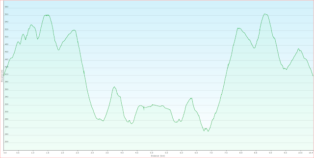
From here I headed down and then up to the final Thumb before starting the long descent to a saddle way below. It was very rocky going down before the country opened up and became an open dry forest which was very pleasant to walk through.
 |
| From western end of last thumb |
 |
| Heading down from last thumb |
 |
| Nice open forest walking |
 |
| Nice open forest and next hill to climb in the distance |
I walked across the saddle and started the ascent of the next hill. It was still easy walking and very little scrub. It did not take long to reach the summit where there were some good views out to the west.
 |
| To the west |
 |
| To the west |
 |
| Starting the descent |
 |
| Donkeys Track Point |
From here I could see the hill where Donkeys Track Point is located and started the final descent to another saddle before beginning the climb up to Donkeys Track Point. From the saddle there were limited views of Orford.
 |
| View of Orford from last saddle |
 |
| Heading up to Donkeys Track Point |
 |
| Donkeys Track Point |
 |
| Donkeys Track Point and lunch spot |
The climb up to Donkeys Track Point was not much and I soon arrived at the destination. Basically it is a large flat area on top of a hill. It is very nice forest and easy walking. I stopped for lunch before having a wander around and then started heading back. I took a slightly different route back to the second saddle but it was not a good idea as it was more scrubby and I ended up descending more than I needed to...the direct route is the preferred route. I climbed back up to the last thumb and that was a bit of a drag, crossed over it and climbed up to the trig marker. I managed to take a couple of shots up near the top
 |
| Orford |
 |
| Orford |
From here it was an easy amble downhill to the car via the forest loop walk.
This was a good walk through some nice forest but it was also somewhat tiring due to the ups and downs. The majority of the walk is off track but navigation is quite easy.
Distance: 10.4 kms.
Time: 5'55
Ascent: 915 metres
Click here to download GPX file.


No comments :
Post a Comment