Pages

Thursday, 29 January 2015

Blakes Opening

Wednesday 28th January 2015

Blakes Opening
Some friends expressed a desire to check out the Huon Track so we opted to walk along the track to Blakes Opening and return. I had previously done the walk last year. See write up and maps etc. here.
To reach the walk start we drove out from Judbury and went via some back roads including Weld, Southwood, Edwards, Edwards Link, Arve, Picton, Riveaux and Quartz Quarry. This considerably shortened both the distance and time it took to get there.
We set off under overcast skies along the first section of track to the registration shelter. The track had recently been cleared so I was hopeful that all the fallen trees further along the track would have been removed also. Alas, this proved to be not so, although a few had been cut closer to the start. We dodged and weaved under and over trees in the first uphill and downhill sections and after that it was not too bad.
We found a great spot down by the river for morning tea with a large log to sit on. It was very peaceful and there was a good flow in the river. We carried on to Blakes Opening where we had an early lunch and then headed back to the car. On the drive home we had the privilege of seeing a mother wombat and small baby by the side of the road. Unfortunately they were too quick for us to be able to get a photo.
A good reasonably flat walk along the Huon River. With the extra people and longer stops it took 6'45" to complete the walk which was exactly a hour longer than I took solo.
Fungi

Huon River

Huon River

Huon River

Fungi

Remains of the hut at Blakes Opening

Blakes Opening

Monday, 19 January 2015

Dora Falls

Monday 19th January 2015

Dora Falls
As we had some recent rain I figured that there should be a good flow over Dora Falls, so I decided to check it out. I had no information on the falls or access so just made something up. As it turned out I ended up driving much further than necessary and also walked further than I needed to, but that was okay, as I was not in a rush.
To reach the walk start, I drove up Judds Creek Road from Judbury to White Timber Trail and turned left and followed the forestry road for 10.5 kms. before turning left and driving down to the start. I could have simply driven up Jacobsons Road from Judbury which is much shorter. I was not sure if this road was gated or not so I checked it out on the way home and it was all clear. I could have also driven much closer to the falls, but was not sure of the roads in the area.
Forestry Road
I set off down a forestry road which eventually crossed Dora Creek, which was flowing well, so I had high expectations that the falls would be good. after a short while I came to an old track on the left and walked down this towards the creek. I could hear that it was flowing well. The track did a right angled turn and shortly after this I headed into the scrub and walked down to where I thought the falls were. It was very steep going and when I eventually reached the creek bed there were no falls to be seen. I only had rough coordinates so I had to go searching. Of course I chose the wrong direction and headed upstream. I had only gone a short distance and decided that it didn't look like there were any falls in that direction. Once I headed downstream a 100 metres or so I came to the top of the falls. They were quite spectacular from what I could see over the edge. I then had to climb up and then down to the base of the falls. There were great with a very good flow. There was so much water that it was creating its own wind.
Dora Falls Top
Dora Creek

Dora Falls

Dora Falls

Dora Falls
Looking over the top of the falls

Dora Falls

I then left the falls and followed a rough track that went along the east bank. I was not sure where it
was heading, but assumed that it was the normal access track. I didn't know if it went into private property or not, and not wanting to upset anyone, I crossed the creek and headed uphill to meet the old track once more and then back to the car.
This was a good walk and the falls were spectacular.
Distance: 7.7 kms.
Time: 4'30"
Ascent: 516 metres
Click here to download GPX file.


Sunday, 11 January 2015

Mount Styx

Sunday 11th January 2015

On Mount Styx Plateau
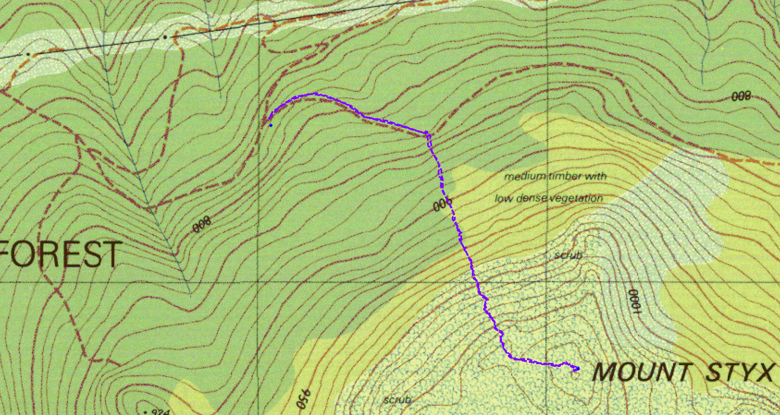
I was going to do Mount Styx last November but forestry had one of the access roads that I wanted to use closed at that stage, so it was put off until now. The route I wanted to use, and in fact the one we did use was now open as I had checked with Forestry on Friday. The normal way to reach the start is to drive out past Maydena and to turn into Styx Road and then Andromeda Road and Jacques Road to the quarry. We drove up from Judbury via Plenty Link Road, Plenty Valley Road, Rinadena Road, Lett Road, West Uxbridge Road, Styx Link Road, Styx Road to Andromeda Road etc. Styx Link Road was supposedly closed going by the signs but the gates were unlocked and Forestry had assured me it would be okay. It took about one and a quarter hours to drive from Judbury which is much less time than the other way.
Walking Track near start
We parked at the quarry and walked up the road which soon deteriorated and became an overgrown track. After about 600 metres we found the tapes for the start of the track and commenced our walk uphill. The track varied from forest to boulders and low shrubby stuff on the plateau near the summit.
It was an easy, short, casual walk with magnificent views from the summit. The day was perfect with mild temperatures, very little wind and mostly clear skies. It seemed one could see for ever. After a very early lunch we walked back down to the cars and returned home the way we had come.
Distance: 4.2 kms.
Time: 3'30"
Ascent: 320 metres
Click here to download GPX file.
From Summit

From summit

From Summit

From Summit

From Summit

From Summit

From Summit

Summit Cairn


Road Access
Click here to download GPX file for Road access. It pays to check with Forestry Tasmania, Derwent office, for road information in this area.

Wednesday, 7 January 2015

Mount Jackson

Wednesday 7th January 2015

Mount Jackson
Mount Jackson is a smallish mountain north west of Judbury and can be accessed from Puzzle Road. However, is is only a short walk, so to make it worthwhile I decided to walk from a road off Plenty Link Road to check out some of the forestry tracks in the area. It turned out to be quite a good walk in the end.
To reach the point where I started, drive out from Judbury heading west, and at 5.5 kms. turn right into Plenty Link Road and follow to a road on the right at 488337 5248034. Drive down 1.3 kms. to a cross roads and park.
Puzzle River

The track headed downhill to the Puzzle River which was only flowing slightly. I had been here last year when I walked to Rimons Hill, and there was more water in it at that time. After the river the track climbed steadily and met up with another track that passed through a pine plantation. It was very pleasant walking through here.
Walking through the pine plantation.
I soon reached Puzzle Road and turned right and walked along for just over a kilometre before taking the Mount Jackson track on the left. The track was quite a good road and could probably be driven in an ordinary car and was not very steep. The track sidled around the western side of the ridge and once I got higher the views started to appear. Up towards the summit were flat sections of rock which provided an outlook to the east. The track actually ended before the summit, but a small scrub bash brought me to the uppermost flat section where I stopped for a snack.
Looking East

Looking North East

Flat section where I stopped

Looking North West
 From there I walked over to the cliffs and along the top of the cliff line in a southerly direction. The country and views were much better than I had expected even though there was evidence of forestry harvesting in the valley below. The cliffs were rather high, and, as I wanted to walk back to Puzzle Road through the bush, I had to keep going along the cliffs until the country became less steep.
Looking North West

Looking North West

Looking West

Looking over the edge

Cliffs

Looking down steeply
There were excellent views all along here.
Looking West

Looking West

Looking West
Eventually I found a gully that headed in the right direction, so I scrub bashed down steeply to an old overgrown track and followed this before walking through a break in the pine plantation to Puzzle Road. From here it was simply a retrace of steps back to the car.
This was a good walk with excellent views from the summit cliffs. Of course it could be made much shorter if so desired.
Distance: 11.6 kms.
Time; 4'20"
Ascent: 530 metres
Click here to download GPX file.