Pages

Friday, 21 June 2013

Pierce Reserve-Goat Hills


Thursday 20th June 2013

It was a cool morning but there was no rain forecast so it looked like a good day coming up. I parked on a sharp bend on Collinsvale road where there is limited parking(2cars at a pinch), although there is more parking about 250 metres back down Collinsvale Road.
I set off walking at 0730 up the Zig Zag Fire Trail. This was quite steep as it zigged and zagged up the hill to eventually meet Dooleys Fire Trail. There were good views of the Collinsvale area and Collins Cap, but Mount Wellington was shrouded in cloud. I took a side road up to a Telstra tower where there were nice views of Hobart and the Derwent and then off track back down hill to Dooleys Trail. This was followed for about 2 kms. to a foot track which led off to the right and up to the crest of a small hill with excellent views of Hobart. It was then back to Dooleys and along to a Telstra Mobile tower then back to Dooleys again. It was somewhere here that I strayed on to private property, but soon found the fence line running along the north west boundary of the reserve, and followed it until it ran out. I should have kept going in the same direction but could see a road below which looked inviting, so I decided to climb down to it and follow. This again proved to be on private property and when I came close to a house, I headed for the hills as I didn't wish to antagonise anyone. This soon led me to Pierces Fire Trail which led back into the reserve where I found a gate with the only private property sign that I encountered. This trail was followed down to intersect the outgoing route and the it was a climb back to the top of the hill and down to the car, which I reached about 1230.
This was an enjoyable walk with excellent views of the Collinsvale area, Collins Cap, Mount Wellington on a clear day, Hobart and the Derwent. There was quite a lot of ups and downs but overall not too bad.
Distance: 13 kms.
Time: 5'00"
Ascent: 1060 metres
There is a map and downloadable gpx file at Everytrail
Click here to download GPX track.
Collins Cap

Looking NW from Zig Zag Trail

Hobart 

Hobart

Hobart

Hobart

Relic of past civilisations


Wednesday, 19 June 2013

Southport Lagoon and Southport Bluff Beach


Sunday 9th June 2013

Note: Due to legal reasons it is now not permissible to walk down the railway line.
 It was an early start today and I arrived at Ida Bay just as the sun was rising. Having parked near The Ida Bay Railway Station I set off walking right on 7.30. This walk can be done two ways. Either commence your walk at the station as I did or catch the Ida Bay Train to Elliott Beach and start the walk from here. This would be the way to go if time was limited. The distance from Ida Bay to Elliott Beach is about 6.5 kms each way.
The first section of the walk was on a old road and after a short distance it met up with the railway line and this was followed all the way to Elliott Beach. At about 1.8 kms. from the start I came across three graves of the Tyler Family at a railway platform overlooking Ida Bay. The line was followed to Elliott Beach where there is a shelter for the rail passengers and turn around for the train. The walking track started from here and lead down to Southport Lagoon. There is a junction on the track to Southport Bluff Beach so note this for the return trip. The Lagoon beach is a still water beach and quite pleasant with good views of the mountains across the water.
I then walked the beach in a southerly direction to the rocks and began a quite long section of rock hopping around the point to eventually end up at Southport Bluff Beach. There were a few boats out fishing and three somewhat keen surfers catching a wave. The Bluff Beach is open to the weather so there were some reasonable waves. I walked along the beach to the Bluff hoping to check out the monument for a shipwreck up on the top, but unfortunately the area is quarantined due to the presence of a rare plant. Undeterred I backtracked down the beach trying to find the exit and eventually located it about halfway along and marked by a pole. This track was followed back to the previously mentioned junction and then back to Elliott Beach where I had lunch sitting on the rocks by the water at the end of the railway line.
Once I was refreshed it was back along the line where I happened to meet the train which was packed with passengers, most of whom gave me a wave. The rest of the walk was uneventful although I kept an ear open for the train coming up behind me and eventually reached the car about 2pm. The walk is about 24 kms. in total if doing the entire trip or about 11kms. if catching the train, and or course each beach could be done individually. Overall a pleasurable walk.
Distance: 23.6 kms.
Time: 6'30"
Ascent: 240 metres
There is a map and description at Everytrail
Click here to download GPX track.

Sunrise

Rail Line

Southport Narrows

Shelter at Elliott Beach

Rock Hopping around the Point

Evidence of someone's misfortune

Southport Bluff

Ida Bay Train


Monday, 17 June 2013

Old Convict Road


Saturday 16th June 2013

The Old Convict Road starts in Orford just over the Prosser River bridge on the North side.
The day dawned overcast and drizzly but I decided to go for a walk anyway. The trip up to Orford took about 1.5 hours and it was showering most of the way. Undeterred, I set off in a light shower towards the Convict Ruins which I reached in about 20 minutes. The ruins consist mostly of piles of rocks but some parts of buildings can be recognised including what looks like the floor of a building made out of cobble stones. After a few photos the track continued on uphill to a power line and then via a foot track up a ridge to almost the summit of a hill before descending to an old track which was followed down to Burnt Bridge Creek. The track became the Old Convict Road once again and was quite easy to follow along the Prosser River for a time until it became indistinct once more, but thankfully someone had added pink tapes which make progress somewhat easier. After this section the road was more obvious and easy walking along the banks of the river. I had no real destination in mind, but when I reached the flying fox which spans the river I decided enough was enough as I was somewhat soaked. Once I had finished lunch the return journey was completed in fairly quick time and needless to say it started raining again when I was almost back to the car. Overall not a bad walk despite the weather.
Distance: 13.1 kms.
Time: 4'30"
Ascent: 550 metres
Click here to download GPX track.
Convict Ruins
                                                   
Flying Fox
                                                   
Prosser River
                                                 
Convict Ruins
                                               
Convict Ruins
                                                     
Convict Ruins


Wednesday, 10 April 2013

Mount Direction

Wednesday 10th April 2013

Summit Cairn Mount Direction
Mount Direction is a short walk in the Hobart area and the walk starts at the Risdon Brook Reservoir.
I walked across the dam wall at the reservoir and along the track on the left side before turning off on to another track and walking up hill to find the track to Mount Direction heading off on the left.
Reservoir Wall
The track climbed steadily uphill and became steep in a few sections. I reached the summit 1'30" after setting off. There were great views of Hobart and surrounds. I then walked back downhill for about 400 metres and then headed off track in a northerly direction along a ridge and the down to a road. From here I just followed the road back to meet the outward leg and continued down, before going off track to meet the track running around the reservoir. I then walked back to the car along the banks of the reservoir. There was a group of people sailing model yachts on the other side, which I watched for a while. It was quite interesting.
A nice short walk with good views on a clear day.
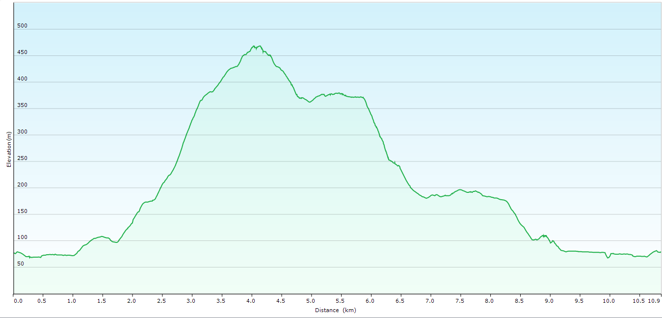
Distance: 10.9 kms.
Time: 3'38"
Ascent: 500 metres
Click here to download GPX track.
Mount Direction Summit

From the Summit

From the Summit

From the Summit

Risdon Brook Reservoir

Yacht racing on the Brook


Monday, 25 March 2013

Tom Thumb Circuit

Monday 25th March 2013

Summit cairn Tom Thumb
I parked in the large car park just uphill from Big Bend and set off walking at 0757. It was a beautiful clear day with a mild temperature so all was looking good. I walked back downhill to the Big Bend Trail which descended for 3.3 kms. to a cairn marking the start of Tom Thumb ascent.
Big Bend Trail
The climb to Tom Thumb summit was short and only took about 20 minutes. The views from the summit were very good. After a break I climb back down to the Big Bend Trail and carried on passing the Knights Creek Track on the right before meeting up with the East West Trail. I followed this for a while to the Myrtle Forest Trail junction and was met with a sign saying that the East West Trail was closed due to the fire damage. It had a phone number so I rang the ranger and was told that, indeed , the trail was open and they had missed taking down the sign. Thankful I carried on, now uphill to the Collins Bonnet Track and then more uphill to Mount Connection. As I reached the summit I deviated off track to check out The Lectern and Pulpit Rock, both worthy of a visit, and then back to the main track again. Eventually I reached the Big Bend Trail and completed the final climb to the car.
This was a good walk with great views around the Mount Wellington area. There is a bit of up and down but it is not too bad.
Distance: 15.6 kms.
Time: 6'10"
Ascent: 764 metres
Click here to download GPX track.

                                                          Various views from Tom Thumb Summit


                                                                  Various views from The Lectern


On the Collins Bonnet Track