Pages

Sunday, 26 June 2016

Wellington Falls Circuit

Sunday 26th June 2016

Wellington Falls
I started the walk at The Springs and headed out on the Milles Track towards Wellington Falls. The track was quite wet and muddy and frosty as well in places.

Milles Track

Hobart waking up

Milles Track

Milles Track

Milles Track
After about an hour and a quarter I reached Disappearing Tarn which was supposed to have water in it. That was the case and it was the first time I had seen it that way, which was a bonus. The water was a lovely greeny/blue colour and there were gas or air bubbles rising to the surface.


The rocks around the tarn were frosty so care had to be taken. I then carried on across The Potato Fields and on to Wellington Falls which were flowing rather well.

Potato Fields

Potato Fields

Potato Fields


Top section Wellington Falls

Start of the Falls

River Cliffs
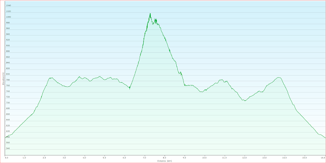
Once I had checked out the falls I walked down the Wellington Falls Track and Pipeline Track to the Snake Plains Track junction. I walked up this for a short distance and stopped for lunch. After the break I continued on up the track to intersect the Milles Track again and then back to the car. Snake Plains was rather wet and muddy in places but easily negotiated.

Snake Plains Track

Cathedral Rock from Snake Plains

This was a good longish walk and it provided a great opportunity to stretch out the legs.
Distance: 19.0 kms.
Time: 6'06"
Ascent: 725 metres
Click here to download GPX file.


Saturday, 18 June 2016

Southport Lagoon and Southport Bluff Beach

Saturday 18th June 2016

Southport Lagoon Entrance
 Note: Due to legal reasons it is now not permissible to walk down the railway line.
We parked at The Ida Bay railway station and set off walking along Ida Bay Road to meet the railway line at Donnellys Gate. There is always the option to catch the train down to Deep Hole at Elliott Beach and walk from there, but as there are only two trains a day during winter, this would not provide enough time to do the walk that we did. The walk to the lagoon would be possible but probably not much else. See Ida Bay Railway for information.
The distance from the start to Deep Hole is about 6.5 kms. and that is mostly along the railway line, either beside the tracks or between them, and is easy walking. We stopped at the graves beside the track at Ida Bay and then carried on to Deep Hole for a snack stop at the shelter at the end of the line.

Ida Bay

Elliott Beach

Looking across Southport Narrows to Southport
From Deep Hole we walked down to Southport Lagoon. The track was quite wet from recent rain but easily negotiated. The tide was low so walking along the beach was easy and negotiating the rocks around the point at the Lagoon entrance was okay as they were not too slippery.

Southport Lagoon

Southport Lagoon with Moonlight Ridge in background

Southport Lagoon

Southport Lagoon

Southport Lagoon

Southport Lagoon
We could hear the surf as we approached the entrance and along the rocks near Southport Bluff Beach we stopped for lunch.

Ocean side of the Lagoon entrance

Ocean side of the Lagoon entrance


From Bluff Beach

Bluff Beach

Bluff Beach

We then carried on to Bluff Beach and found the marker for the access track and proceeded to walk back to Deep Hole and then the car. By the time we reached the car we were both a bit weary, but not too bad, after walking about 24.0 kms.
See previous post here for more information.


Tuesday, 14 June 2016

Mount Dromedary

Monday 13th June 2016

We went for a hike up to Mount Dromedary today. The outward leg was via the normal route and then up the west face which was a little slippery in places due to the wet rocks. Up at the trig marker on the summit it was blowing a gale and it was trying to blow us off our feet. We did not waste too much time here and headed over to the eastern lookout for lunch in a somewhat more  sheltered spot. I decided to head back down the southern track because it provides a much more gentle slope with less likelihood of accidents. This proved to be a good idea. Once we reached the old road we headed back to the car via the track that runs to the western side of Little Marsh. I always like to walk this section because it has a nice feel about it. The creek that drains the Marsh was running really well.
This a really good walk with 360 degree views from the summit. I did not take many photos as there are plenty in previous posts.
Distance: 16.0 kms.
Time: 6'18"
Ascent: 690 metres
Click here to download GPX file.

Platform Peak

The Derwent

Mount Dromedary Summit


Saturday, 4 June 2016

Pelverata and Slippery Falls

Saturday 4th June 2016

Pelverata Creek
There is not much of a narrative for this walk as it is covered in a previous post here. There was less water in the creeks than last time and the ground was quite frosty in places. On the return journey we did come across a large group of people and many 4WDs participating in a cleanup of the Snug Tiers area. They even had burnt out cars on trailers ready to take out. Good on them, I say, but it is just a shame that they have to do that. Why people can't have more respect for reserves like this, or the bush in general, I do not know.

Frosty sawmill site

Old sawmill boiler

Top of Pelverata Falls

Top of Pelverata Falls

Pelverata side creek

Looking out to the Kaoota area

Top of Slippery Falls

Pelverata Falls from Slippery Falls