Pages

Tuesday, 27 March 2018

Craigow Hill

Tuesday 27th March 2018

Summit Craigow Hill
I wanted to do a longer walk today, something with some uphill and some ups and downs and Craigow Hill seemed to be a good choice.
I started off from the car park in Belbins Road and headed up the old 4WD track before walking along one of the many bike tracks in the area. Once the bike track finished at the top of Golden Hill, there was a steep descent to Cross Rivulet which was almost dry.

Bike Track

Craigow Hill

Cross Rivulet

Cross Rivulet
Once across the rivulet I followed the track along the rivulet for some time before climbing quite steeply up to Craigow Hill. This was a track that I had not been on before. Craigow Hill was much as I remembered from previous visits with grass trees on top. The sun was in the wrong place for photos but I took a couple.

Craigow Hill

Craigow Hill

Craigow Hill
From the hill I headed north and walked a little loop where there were views over Hobart.

Hobart Views

Looking North
I then walked back and followed the normal route along to Eagle Hill and then descended once more to Cross Rivulet. It was totally dry here. The track kept going to Flagstaff Hill where the quarry has expanded since I was last here. There were no entry and blasting in progress signs near the quarry so to kept everyone safe and happy including me, I took a shortcut through the bush down to the track. It was not far.

Hobart

Hobart and Mount Wellington
I kept going along the track before taking the Clifftops bike track where there are views from the cliffs.

Hobart and Derwent

Hobart

Cliffs

Hobart

More Hobart.
Kept going down to the bike park and then along the track beside the highway back to the car.
A good walk with good views over Hobart. I got in my uphill and my ups and downs, so I was quite satisfied and I tried out a few tracks that I had not been on before.
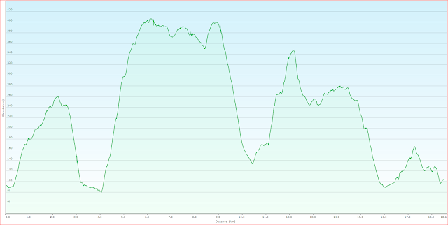
Distance: 18.6 Kms.
Time: 6'04"
Ascent: 970 metres
Click here for GPX file.


Friday, 16 March 2018

Sullivan Point

Friday 16th March 2018

Sullivan Point
Sullivan Point is located on the western end of Little Lagoon Beach in the Southport Lagoon area. It is one of my favourite beaches in the south east as it usually deserted and gives one the feeling of being isolated. The walk starts at the end of South Cape Spur 1.
It was an overcast morning and a bit dreary but there was no rain. There was another track that I wanted to check out so I headed off on the Big Lagoon Beach track. The mountains to the west were a little indistinct in the gloom.

To the west

Button Grass Plains
After about 45" I located the track that I wanted and followed it until it almost met the Little Lagoon track. This track was reasonable but is slowly overgrowing. At the end of this track I turned south east and walked towards Eliza Point, initially along a fence line and then an old almost non existent track which has overgrown more since I was here last.

Walking along the fence line.
After some scrub bashing when trying to locate the route I finally reached Little Lagoon Beach which was just as nice as it usually is.

Eastern end Little Lagoon Beach

Little Lagoon Beach
I walked the length of the beach to entrance of Black Swan Lagoon and sure enough there were plenty of swans there.

Little Lagoon Beach

Towards Sullivan Point

The Images

Black Swan Lagoon
I kept going to Sullivan Point and wanted to cross over to the western side on Recherche Bay so I looked for a track but did not see one so just walked across through the bush which was quite easy. As I reached the other side I did locate a track which I would follow back eventually. Over this side of Sullivan Point was really quite nice as well, so I sat on the rocks for a well earned break.

Recherche Bay

Recherche Bay

Fishers Point

Sullivan and Fishers Points
After a while I headed back on the track which went to Quiet Cove and then back to Little Lagoon Beach. Not sure how I missed it on the way in as it was quite obvious. It is private land in the middle of Sullivan Point but a sign shows that access is permitted.

Quiet Cove

Quiet Cove


Once back on the beach I started walking back towards the car via a track that provides a good view of Black Swan Lagoon.

Surf Rolling in
Black Swan Lagoon

Black Swan Lagoon

View from track heading back
The Little Lagoon track is overgrowing also with button grass and cutting grass and is quite indistinct in places. Someone has placed a few tapes here and there which makes it a little easier. I made it back to the car in a shorter time than I had expected.
This is a really nice walk but expect some scrub and cutting grass which will only get worse with time, but the beach and surrounds are worth the effort.
Distance: 16.9 kms.
Time: 4'53"
Ascent: 250 metres
Click here for GPX file.


Tuesday, 6 March 2018

Moonlight Ridge

Tuesday 6th March 2018

Small tarn on Moonlight Ridge
The Moonlight Ridge track is generally used for access to the South West National Park for multi day walks but it is also a great day walk just up to the ridge itself. The scenery up there is quite spectacular.
I parked in Limestone Quarry Road off South Lune Road near Ida Bay and headed off quite early. The first section of track went to the quarry along the route of the old railway line and was fairly flat.
After that it climbs, quite steeply in places before coming to a saddle where it is relatively flat for a short time, and then climbs again all the way to Moonlight Ridge. It is mainly rain forest type country all the way up. There were plenty of fungi of various colours and shapes.


The first views started to appear about the 700 metre elevation and once up on the ridge it is fairly flat. There were 360 degree views and it was another perfect day.

Adamsons Peak

Moonlight Ridge

Another Tarn


Moomlight Ridge

Recherche Bay

Southport Lagoon

Lune Sugarloaf, South Bruny Island, Cape Raoul
I spent about half an hour wandering around on top of the ridge to get various views of the mountains and coast before heading back down. The weather remained perfect for the whole day.
This is a great walk with stunning views once up on top but there is a bit of a climb to get there. I reckon it is worth it. Of course it is possible to carry on further as far as you like.
Distance: 12.7 kms.
Time: 6'16"
Ascent: 770 metres
Click here for GPX file.